
So we talkin 4 buses? I gotta find an alternate spot.
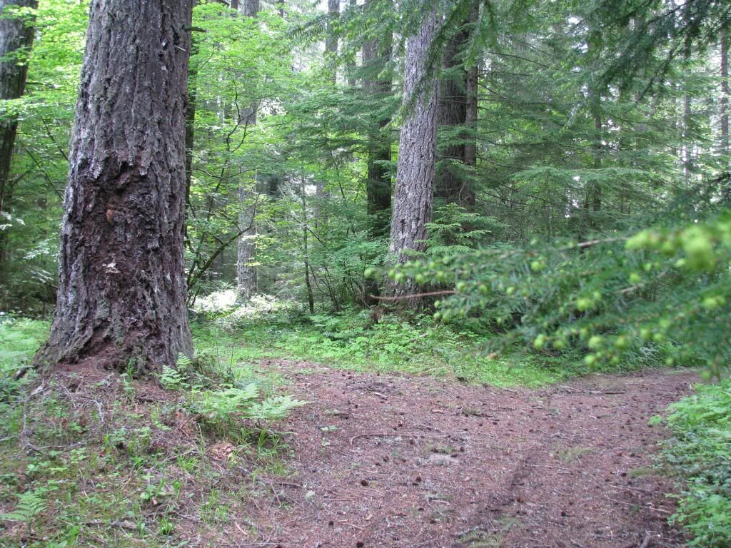
South Fork Mountain is incredible but it may be chilly up there.
Mid-September - Mid-Cascades 2009?
-
hambone

- Post-Industrial Non-Secular Mennonite
- Location: Portland, Ore.
- Status: Offline
http://greencascadia.blogspot.com
http://pdxvolksfolks.blogspot.com
it balances on your head just like a mattress balances on a bottle of wine
your brand new leopard skin pillbox hat
http://pdxvolksfolks.blogspot.com
it balances on your head just like a mattress balances on a bottle of wine
your brand new leopard skin pillbox hat
-
Gypsie

- rusty aircooled mekanich
- Location: Treadin' Lightly under the Clear Blue!
- Status: Offline
Maybe 5. Rhondabus has signed on here but hasn't posted. I saw her today and she and her partner are ready to get out into the backwoods with their recently repaired bus.
Gonna have to wear my suit as she works at one of the buildings I manage and I have to keep up appearances....
Riiiiight.
The Dub is strong in this one...
Gonna have to wear my suit as she works at one of the buildings I manage and I have to keep up appearances....
Riiiiight.
The Dub is strong in this one...
So it all started when I wanted to get better gas mileage....
-
justgimmecoffee

- Old School!
- Location: Hawaii
- Contact:
- Status: Offline
-
hambone
- Post-Industrial Non-Secular Mennonite
- Location: Portland, Ore.
- Status: Offline
It's really weird you brought that place up, I've been really thinking about it...Jasan and I went up there last year, it's a great place. Very jungly, right on the rim of the Roaring River. 4611 dead ends at a weird 3 way crossroad of sorta-roads going back to the earth. There was a good camp past a big puddle at that junction. The road in is as crazy as Hambone-Abbot but in a flat way. Used to be a logging railroad grade around 1910 then became a "road". You'd like it. It would also make for a very spooky Hunter's Moon camp, maybe something to consider.
Here's last year if you have way too much time on your hands:
viewtopic.php?t=4333
The more I think about it, S. Fork Mountain seems perfect.
What about this. Since S. Fork Mtn. is 5000', a cloudy weekend wouldn't be much fun up there. We'll see what Ma throws our way and decide in a couple days. They're both about the same distance from Portland.
We must channel the earth for the future unknown group vibe.
Whattyathink?
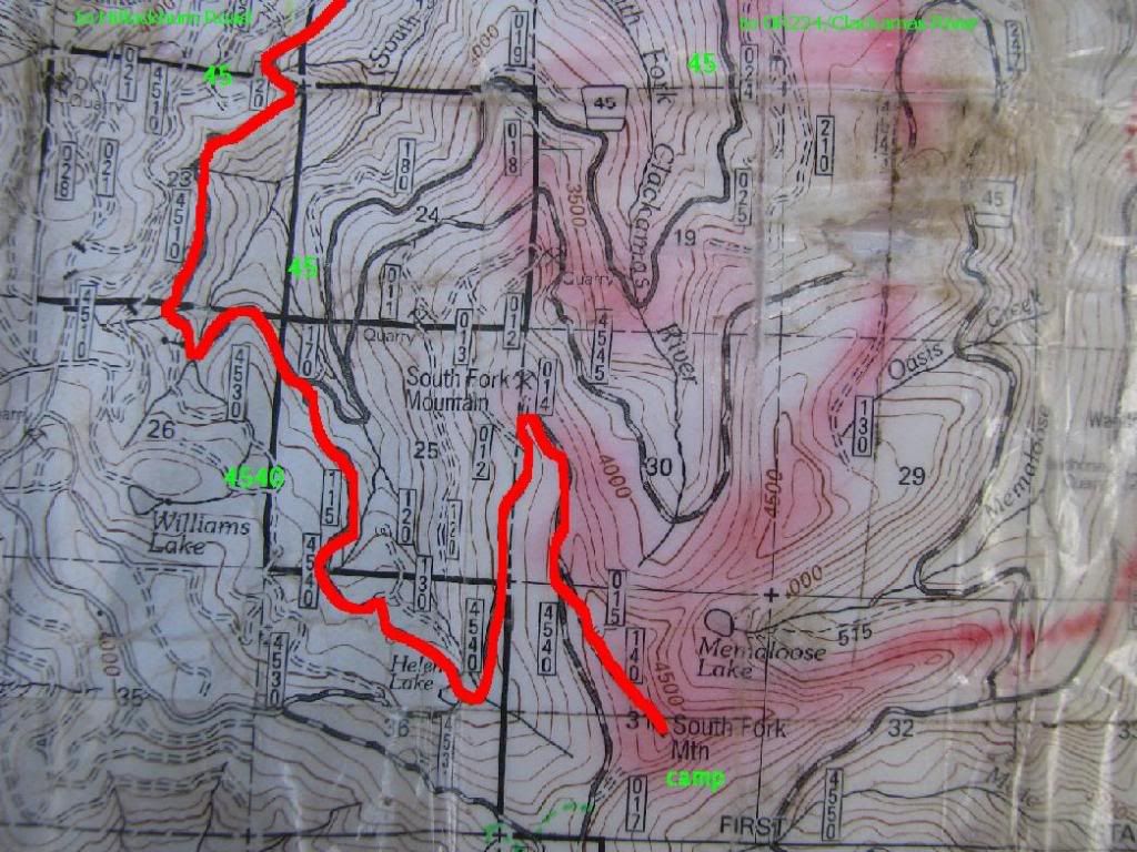
Grouse-Huxley Camp
at the end of FS 4611.
http://maps.google.com/maps?f=q&hl=en&g ... 7&t=p&z=15
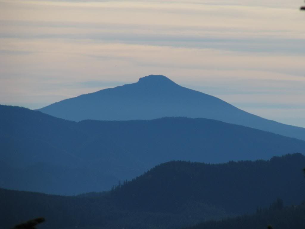
a view from South Fork Mountain
Road to the top not shown on map but ez to find.
http://maps.google.com/?ie=UTF8&t=p&ll= ... 38238&z=15
Here's last year if you have way too much time on your hands:
viewtopic.php?t=4333
The more I think about it, S. Fork Mountain seems perfect.
What about this. Since S. Fork Mtn. is 5000', a cloudy weekend wouldn't be much fun up there. We'll see what Ma throws our way and decide in a couple days. They're both about the same distance from Portland.
We must channel the earth for the future unknown group vibe.
Whattyathink?
Grouse-Huxley Camp
at the end of FS 4611.
http://maps.google.com/maps?f=q&hl=en&g ... 7&t=p&z=15
a view from South Fork Mountain
Road to the top not shown on map but ez to find.
http://maps.google.com/?ie=UTF8&t=p&ll= ... 38238&z=15
http://greencascadia.blogspot.com
http://pdxvolksfolks.blogspot.com
it balances on your head just like a mattress balances on a bottle of wine
your brand new leopard skin pillbox hat
http://pdxvolksfolks.blogspot.com
it balances on your head just like a mattress balances on a bottle of wine
your brand new leopard skin pillbox hat
-
hambone
- Post-Industrial Non-Secular Mennonite
- Location: Portland, Ore.
- Status: Offline
Looking like mid 70s up on S. Fork and mostly sunny for the weekend.  We'll see if that lasts.
If we do wind up there, can someone bring firewood? There's not much down stuff in the area.
4 more days, you guys getting excited?
If we do wind up there, can someone bring firewood? There's not much down stuff in the area.
4 more days, you guys getting excited?
http://greencascadia.blogspot.com
http://pdxvolksfolks.blogspot.com
it balances on your head just like a mattress balances on a bottle of wine
your brand new leopard skin pillbox hat
http://pdxvolksfolks.blogspot.com
it balances on your head just like a mattress balances on a bottle of wine
your brand new leopard skin pillbox hat

-
hambone
- Post-Industrial Non-Secular Mennonite
- Location: Portland, Ore.
- Status: Offline
FWIW I'm not bringing any! 
Always somethin laying around out there. Don't sweat it.
I'll be out there Thursday night or Friday AM if anyone wants to haul out there with me. I'll post detailed directions (and plan B you never know) in a couple days.
John, you should consider I5 N to OR211 NE to Hillockburn Road (about 5 miles or so before Estacada) if we do indeed go to S. Fork. Once in the forest it's a pretty quick (potholed) drive. You gotta work Friday?
http://maps.google.com/?ie=UTF8&ll=45.2 ... 13754&z=16
http://greencascadia.blogspot.com
http://pdxvolksfolks.blogspot.com
it balances on your head just like a mattress balances on a bottle of wine
your brand new leopard skin pillbox hat
http://pdxvolksfolks.blogspot.com
it balances on your head just like a mattress balances on a bottle of wine
your brand new leopard skin pillbox hat
-
hambone
- Post-Industrial Non-Secular Mennonite
- Location: Portland, Ore.
- Status: Offline
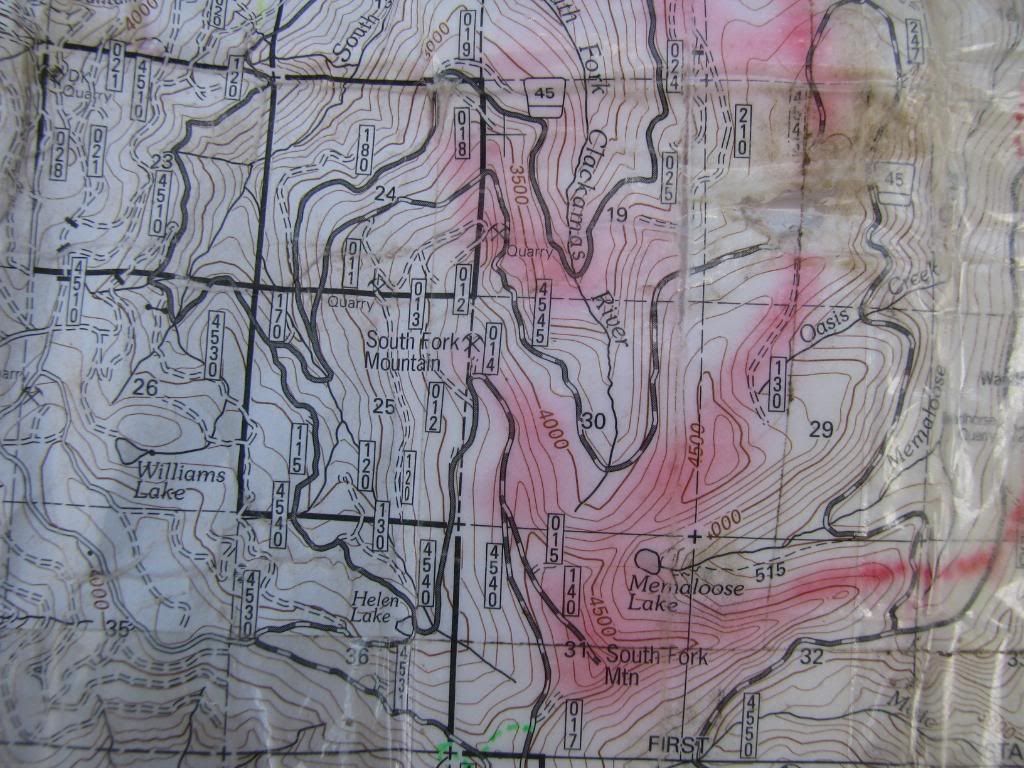
Maps, eh good enough:
http://greencascadia.blogspot.com
http://pdxvolksfolks.blogspot.com
it balances on your head just like a mattress balances on a bottle of wine
your brand new leopard skin pillbox hat
http://pdxvolksfolks.blogspot.com
it balances on your head just like a mattress balances on a bottle of wine
your brand new leopard skin pillbox hat
-
deschutestrout

- IAC Addict!
- Location: Maupin, Oregon
- Contact:
- Status: Offline
-
hambone
- Post-Industrial Non-Secular Mennonite
- Location: Portland, Ore.
- Status: Offline
Sorry guys those maps really suck...
It's easy though. Hillockburn Road turns into 45. You pick that up from 211. Then the map should help. All my nice text turned to crap in Photobucket.
You guys should have Clackamas District maps at this point anyway.
It's easy though. Hillockburn Road turns into 45. You pick that up from 211. Then the map should help. All my nice text turned to crap in Photobucket.
You guys should have Clackamas District maps at this point anyway.
http://greencascadia.blogspot.com
http://pdxvolksfolks.blogspot.com
it balances on your head just like a mattress balances on a bottle of wine
your brand new leopard skin pillbox hat
http://pdxvolksfolks.blogspot.com
it balances on your head just like a mattress balances on a bottle of wine
your brand new leopard skin pillbox hat

-
hambone
- Post-Industrial Non-Secular Mennonite
- Location: Portland, Ore.
- Status: Offline
Well, you should! No sense getting lost out there. It's confusing with so many logging roads. Besides I'm pretty sure I got you one already Mr. Troublemaker. Oh that crazy GPS thing I'd rather use my imagination. I'll bet the map is more accurate out there anyway. $6 how can you go wrong?Gypsie wrote:Uh oh, I'm gonna get a demerit.hambone wrote:You guys should have Clackamas District maps at this point anyway.
Chitown be careful man, we may turn you into latte swilling tree hugging snobs. Hell I'll bet we already did but you're still
in the closet. Be careful though they can SMELL it on you.
Last June at S. Fork: viewtopic.php?t=6469&start=15
ANDSouth Fork Mountain is a mountain summit in Clackamas County in the state of Oregon (OR). South Fork Mountain climbs to 4,833 feet (1,473.10 meters) above sea level. South Fork Mountain is located at latitude - longitude coordinates (also called lat - long coordinates or GPS coordinates) of N 45.09151 and W -122.240359.
http://www.mthood.info/hikingtrails/mem ... ake515.pdf
http://greencascadia.blogspot.com
http://pdxvolksfolks.blogspot.com
it balances on your head just like a mattress balances on a bottle of wine
your brand new leopard skin pillbox hat
http://pdxvolksfolks.blogspot.com
it balances on your head just like a mattress balances on a bottle of wine
your brand new leopard skin pillbox hat